2026-10-09
Content
A single 32 cm terrain globe can carry a whole term of map-reading lessons. The same budget spent on a globe with a plastic clip mount, a 1:15 relief exaggeration and a cardboard base will spend the year on a shelf. The gap between a usable order and a wasted one is almost never about the subject area. It is about diameter, mount, relief scale, wall thickness and packing. The list of geography teaching equipment for one classroom is short, the specification is where money is saved or thrown away, and the receiving inspection is where the argument actually starts.
The sections below set out what to buy, what to write into the purchase specification, and what to check on the day the shipment arrives.
Geography teaching equipment falls into five working groups, and each group has one specification that decides whether the item will actually be used in class. Orders that treat the whole list as "maps and globes" usually end up short of the three-dimensional pieces that carry the difficult content: earth structure, plate movement, moon phases and contour interpretation.
| Group | Typical items | Specification that decides usability |
|---|---|---|
| Globes | Political, terrain (raised relief), celestial and star globes | Actual sphere diameter and the material of the semi-meridian |
| Celestial and orbital models | Sun-Earth-Moon (three-sphere) model, nine-planet solar system set, latitude and longitude model | The drive that moves the Moon and Earth, and the planet scale ratio |
| Structural and landform models | Earth internal structure, fold and fault, crust change, seabed relief, removable contour model | Cut-away depth, label accuracy, shell wall thickness |
| Field and measurement instruments | Prismatic compass, clinometer, geographic theodolite, rain gauge, flow meter | Graduation interval and waterproofing of the case |
| Maps, charts and consumables | Wall maps, outline maps, contour sheets, map pins | Boundary accuracy, lamination, print registration |
A typical secondary school geography budget does not divide evenly across those five groups. In the allocations schools use when fitting out a new geography room, the two model-based groups together absorb roughly two-thirds of the spend, while the field instruments that teachers reach for least often take the smallest share.
Illustrative allocation for one secondary geography room. The percentages show the pattern schools tend to follow, not a quotation.
The practical consequence is simple: the two model groups deserve the longest part of the specification discussion, not the shortest. They are also the groups where one sample unit is worth requesting before a large order is confirmed.
These are the details that generate the most disputes after delivery, and they are all visible in a single sample unit.
Illustrative pattern of the faults found when geography equipment is opened and checked on arrival, expressed per hundred units.
Tolerances worth writing into the purchase order: sphere diameter within 5 mm of nominal, no crack longer than 5 mm, no boundary offset greater than 1 mm, and no more than 2 percent of units with chipped paint or a loose label.
The same model can be excellent in one grade and useless in another. As a working guide:
The money-saving rule is to buy shared items once, at the specification of the highest grade that will use them. A 32 cm globe serves both lower and upper secondary; a 25 cm globe does not. Field instruments work the other way round: a class set of modest compasses is more useful than six expensive ones kept in a cupboard.
Globes come in three families, and mixing them up is the most common mistake in a geography order. A political globe shows boundaries, names and the graticule. A terrain globe shows raised physical relief. A celestial globe shows stars and magnitudes instead of the Earth's surface. Each answers a different lesson, and no single globe covers all three.
Two details decide whether a globe survives a term. The first is the mount: a semi-meridian ring with a weighted base is the standard classroom choice, a full meridian ring is better for demonstrating rotation, and a floor stand suits a demonstration corner. The second is the diameter: 25 cm for primary, 32 cm for secondary, and 40 cm only where a whole class must read the names from a distance.
For a secondary geography room, a raised-relief terrain globe with a metal semi-meridian and a weighted base is a dependable starting point. Ask for the relief exaggeration and the sphere diameter to be stated in the quotation, because those two numbers decide whether the globe becomes a teaching tool or a decoration.
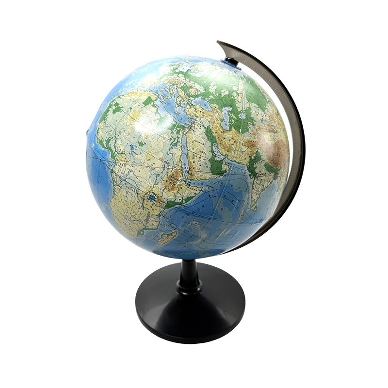 X1259 Educational Terrain Teaching Globe for GeographyA metal-and-plastic terrain globe for junior-high geography teaching, showing mountain and river distribution; useful for introducing Earth's shape and topography.View Product →
Cut-away models do work that a printed diagram cannot, but only when the layer proportions are honest. On an earth internal structure model, the crust is a fraction of one percent of the radius, so a model showing a fat, even crust teaches the wrong thing. The better approach is a labelled exaggeration, applied consistently to every layer, with the exaggeration factor printed on the base.
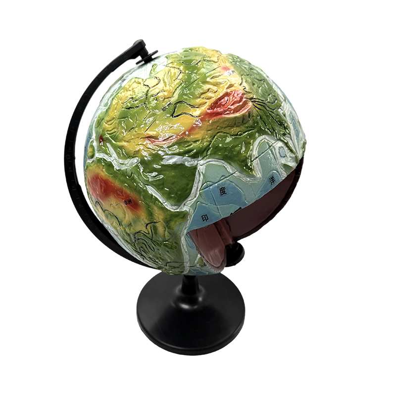 X1260 Earth Internal Structure Globe Model for Geography TeachingA metal-and-plastic classroom model showing Earth's crust, mantle and core, their sequence and thickness, useful for teaching layered internal structure.View Product →
Orbital models are judged by their drive, not their paint. A Sun-Earth-Moon model needs the Moon's orbit plane tilted by roughly 5 degrees and the Earth able to rotate in both directions. A model with a fixed one-way drive can show day and night, but it cannot demonstrate eclipse geometry.
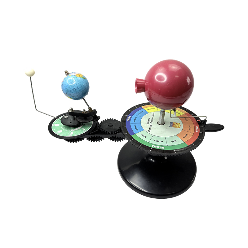 X1254 Sun Earth Moon Orbital Teaching ModelA metal-and-plastic classroom model with Earth, Moon, Sun, four seasons plate and gear set for demonstrating relative motion and orbits.View Product →
Fold-and-fault blocks, crust-change models and removable contour models are the workhorses of physical geography. Look at the locating pins and hinges before the surface finish: a model whose pieces no longer sit flush after a month is finished, however good it looked in the catalogue.
Schools running a full fit-out tend to follow the same sequence: sample first, then the bulk order, then a receiving inspection with the delivery note in hand. Documented school fit-out cases follow that pattern almost without exception.
One 32 cm demonstration globe for the teacher, plus one globe per four to six students for measurement exercises. Globes are shared reading tools; buying thirty for a class of thirty takes budget away from the models.
If the syllabus includes physical geography comparisons, yes. If it is mainly boundaries and place names, buy two political globes and one terrain globe rather than three terrain globes.
Upper secondary classes and astronomy clubs. For middle school, a transparent celestial globe showing the star grid against the Earth is usually enough.
No, but labels and boundary conventions should match the maps students use. Send a few sample pages to the supplier and ask for the labelling to be confirmed before production.
State the packing standard and the replacement rule in one line: any unit cracked in transit is replaced, and the claim is made per unit rather than as a percentage allowance. General selection criteria for school instruments are set out in this note on school laboratory instrument selection.
Geography is one of the few subjects where a single purchase can still be teaching students fifteen years later. That is why the specification deserves more attention than the price list. Write the diameter, the mount, the relief scale, the shell thickness and the packing standard into the order, approve one sample unit first, and inspect the delivery against agreed tolerances on arrival.
Yuyao Xueyou Teaching Equipment Co., Ltd. has manufactured teaching instruments since 2008, covering geography alongside biology, chemistry, physics and mathematics from a 10,000 square metre facility in Yuyao, Zhejiang. Its geography range includes terrain, political and celestial globes, orbital and structural models, and landform models, supplied to schools in more than thirty countries.
Recommended Products


+86-18630650508 +86-0574-62500588

+8618630650508

 No. 588, Chaoyang South Road, Ditang Street, Yuyao, Ningbo City, Zhejiang Province, China


 English
 русский
 Español