2026-07-03
Content
A well-equipped geography laboratory needs four core equipment groups: terrain and landform simulation models, celestial and astronomical demonstration instruments, measuring and mapping tools, and climate and environmental observation devices. Together these categories of teaching instruments let students move from flat textbook diagrams to hands-on, three-dimensional understanding of how the Earth's surface, atmosphere, and solar system actually behave.
Quick answer
Most school procurement lists group geography teaching equipment the same way physics and chemistry labs group their own instruments: by the physical process being demonstrated. A geography classroom rarely needs specialized glassware or electrical experiment equipment the way a chemistry or physics lab does — instead, its budget goes toward durable models and demonstration instruments that can be reused across many classes for years.
| Category | Typical Instruments | Teaching Purpose |
| Terrain simulation models | Contour landform models, fault-fold demonstration models, crust-change models | Show how mountains, valleys, and geological structures form and change |
| Celestial motion instruments | Three-sphere sun-earth-moon models, celestial globes, planetary system models | Demonstrate day-night cycles, seasons, eclipses, and orbital motion |
| Measuring and mapping tools | Theodolite-longitude models, educational globes, scaled topographic maps | Teach coordinates, scale, direction, and spatial measurement |
| Climate and observation devices | Climate observation kits, seabed and underwater terrain models | Introduce weather patterns, ocean topography, and environmental data collection |
| General lab support | Storage cabinets, display stands, science kits for group work | Keep instruments organized and ready for repeated classroom use |
Landform models are usually the first purchase for a new geography lab because they turn an abstract textbook page into something students can rotate, disassemble, and reassemble. A removable contour-line landform model, for example, is commonly built at a size of roughly 595 × 575 × 155 mm and weighs around 3.3 kg in molded plastic — light enough for a teacher to carry between classrooms but sturdy enough to survive years of student handling. Fault-fold demonstration models work the same way for tectonic teaching: layered blocks slide against one another so students can physically see how compression and tension shape rock strata.
A crust-change model extends this idea further, showing how erosion, deposition, and geological time gradually reshape the Earth's surface. These teaching instruments are usually grouped with earth-science kits rather than sold as single items, since a classroom typically needs several landform types on hand to cover a full unit on physical geography.
Contour landform models
Removable layers teach elevation, contour lines, and slope reading without needing an outdoor field trip.
Fault-fold models
Mechanically adjustable blocks demonstrate compression, tension, and rock deformation in real time.
Crust-change models
Illustrate long-term geological processes such as uplift, subsidence, and weathering.
Underwater terrain models
Extend landform teaching below sea level, covering continental shelves, trenches, and seamounts.
Astronomy is the second pillar of most geography curricula, and it is where geography teaching instruments overlap most closely with physics teaching instruments in terms of mechanical design. A three-sphere sun-earth-moon model is the standard tool for teaching day-night cycles, seasonal change, and lunar phases, since a hand crank or motor moves the three spheres through their relative orbits at a visible, adjustable pace.
For more advanced classes, transparent celestial globes and luminous black-star globes let students study constellations and celestial coordinates from both inside and outside the sphere. A typical celestial or theodolite-longitude model measures about 330 × 330 × 340 mm and weighs 1.9–2.5 kg, built from a metal frame with plastic components — heavy enough to stay stable on a desk during a lesson, but still portable between rooms.
| Instrument | Typical Size | Typical Weight | Material |
| Theodolite-longitude model | 330 × 330 × 340 mm | about 1.9 kg | Metal + plastic |
| Luminous black-star celestial globe | 330 × 330 × 340 mm | about 2.5 kg | Metal + plastic |
| Contour landform model | 595 × 575 × 155 mm | about 3.3 kg | Plastic |
Featured Geography Teaching Instruments
A snapshot of the model types most commonly stocked in a school geography lab, covering astronomy, terrain, and ocean-floor teaching in one product line.
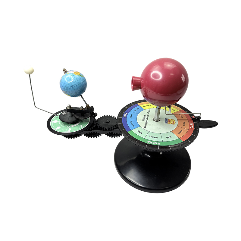
Three-Sphere Sun-Earth-Moon Model
Astronomical Model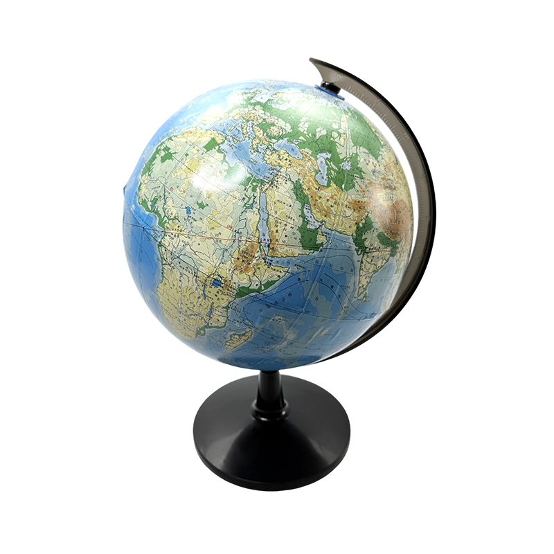
Educational Teaching Globe (Terrain)
Terrain Model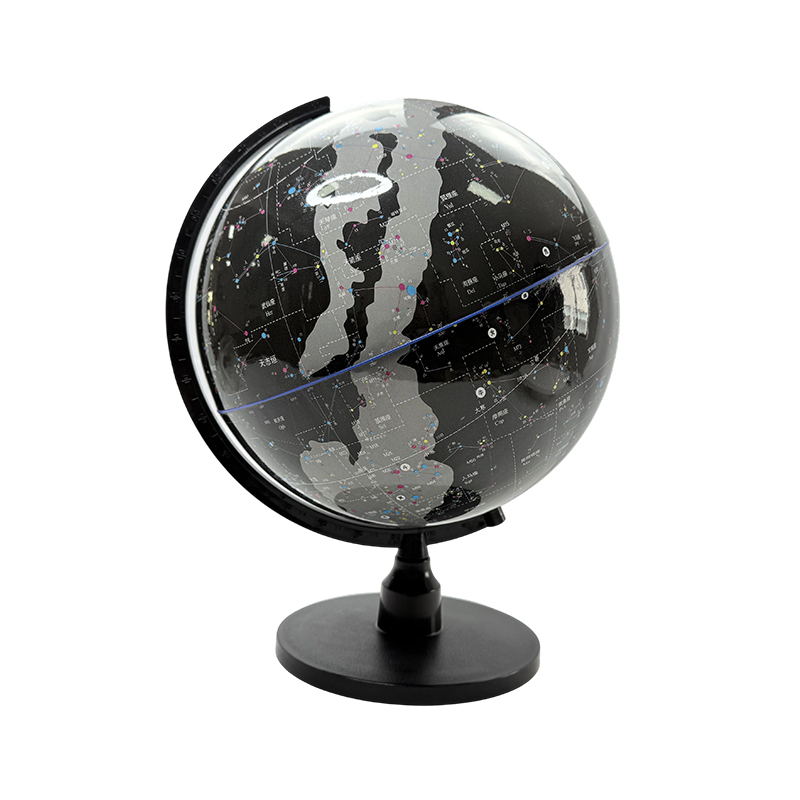
Luminous Black-Star Celestial Globe
Celestial Globe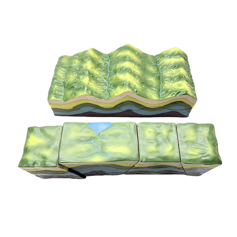
Fault-Fold Geometric Demonstration Model
Geological Model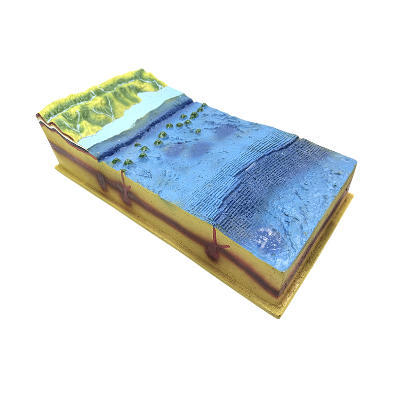
Underwater Seabed Model
Seabed ModelBeyond models that sit on a shelf, a geography lab needs educational measuring equipment that students actually operate. A theodolite-longitude model teaches angle and coordinate measurement, while a standard political or terrain globe reinforces scale, latitude, and longitude before students move on to real maps or GPS tools. These items function much like the laboratory instruments and apparatus found in a physics or chemistry room — precision tools meant for repeated, hands-on use rather than passive display.
Climate teaching is often the most overlooked category when schools first set up a geography lab, yet it is where students apply geography concepts to real, current data. Basic climate observation kits — thermometers, simple rain gauges, and wind-direction indicators — allow a class to build its own weather log over a semester rather than relying only on textbook averages. Paired with a seabed or underwater terrain model, these tools let a single lab cover both atmospheric and oceanic geography without needing separate specialized rooms.
Science kits built for group work are particularly useful here, since climate observation is one of the few geography activities that scales naturally to teams of three or four students collecting and comparing their own readings.
The right equipment list depends heavily on grade level. A primary school needs simple, durable, highly visual models, while a senior high school or university lab needs more precise measuring equipment and a wider range of geological and astronomical models to support exam-level detail.
| School Level | Priority Equipment | Notes |
| Primary school | Basic globes, simple sun-earth-moon models, wall maps | Focus on visual, hands-on exploration over precise measurement |
| Middle school | Contour landform models, celestial globes, compasses, theodolite models | Introduce coordinate systems and basic landform classification |
| High school | Fault-fold models, crust-change models, climate observation kits, precision globes | Support exam-level detail on tectonics, climate, and orbital mechanics |
| University / vocational | Full instrument sets including seabed models, advanced measuring equipment | Supports research-style projects and field-study preparation |
Do all geography labs need celestial instruments? Not every school needs a full astronomy set, but a basic sun-earth-moon model is standard from middle school onward because it directly supports the day-night and seasons curriculum used almost everywhere.
How is a geography lab different from a general science kit room? A geography lab focuses on static and semi-mechanical models rather than the reactive experiments typical of chemistry teaching instruments or the circuit-based setups used in electrical experiment equipment; its instruments are built for repeated visual demonstration rather than consumable experiments.
What is the most cost-effective starting point? Schools on a limited budget typically start with one globe, one sun-earth-moon model, and one landform model, then expand into geological and climate equipment as the curriculum and budget grow.
Recommended Products


+86-18630650508 +86-0574-62500588

 No. 588, Chaoyang South Road, Ditang Street, Yuyao, Ningbo City, Zhejiang Province, China
 English
 русский
 Español